Services
Ermeview Environmental Solutions Ltd is small consultancy based in South Devon providing a range of environmental and technical services to clients. We have extensive experience in flood modelling and it's use in Flood Risk Assessments, data analysis using Geographical Information Systems (GIS) or bespoke solutions, and professional mapping services.
Feel free to contact us if you would like a no obligation discussion about a Flood Risk Assessment, data analysis or a mapping task you have. We will be happy to discuss the requirements and what it may involve.
Flood Risk Assessments
Flood Risk Assessments (FRAs) can vary from small - less vulnerable - local developments to larger developments requiring more detailed analysis. Our extensive expertise in this field and understanding of planning legislation can help us assist you in identifying and undertaking the appropriate level of detail for your site.
We strive to identify the scope and any potential issues at an early stage and ensure that we discuss these with regulatory authorites and stake holders in order to minimise unecessary delays to the planning process. We maintain a client focused mentality and aim to keep you informed of any potential issues and help to resolve them as soon as possible. As a small consultancy we are able to be flexible and adapt to changes in your requirements where necessary.
As part of our flood risk assessment service we can provide the following capabilities:
- Site runoff calculations for developments.
- Flood modelling and hydraulic modelling and analysis
- Flood mitigation proposals, including outline defence design, earthworks, evacuation plans and finished floor levels.
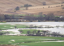
Flood modelling
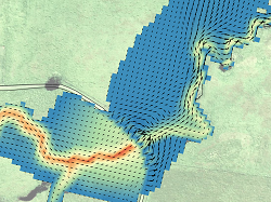
We develop and analyse river models for a variety of clients and purposes. We have extensive
experience in the use of a range of industry standard 1D, 2D and linked 1D-2D software,
including Flood Modeller Pro, TUFLOW, ESTRY-TUFLOW and HECRAS.
We have a range of experience in developing models either from first principles, including
outlining the problem scope and obtaining the necessary data, or updating and improving
existing models. Our considerable experience in dealing with complex models and understanding
of the fundamentals of the relevant software means we pride ourselves on producing robust and
reliable models that accurately represent the flooding mechanisms.
Our client focused approach means that we aspire provide the best service we can, within the scope of the project. By working to better understand the client requirements and undertake an extensive data review we provide specifications that offer the best outcomes for the client. This approach allows us to guide clients through any additional requirements, such as survey and mapping data, as early as possible. It also helps us to ensure that we provide results and outputs in the most suitable format for the project.
Our capabilities
- TUFLOW 2D and TUFLOW-ESTRY 1D-2D.
- Flood Modeller Pro 1D
- HEC-RAS 1D
- GIS systems for model schematisation and results, compatible with MapInfo, ArcGIS and QGIS.
GIS Analysis and Mapping
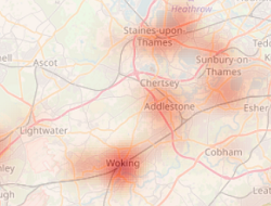
We have extensive experience in a range of GIS (Geographical Information System) software, including propriatary software such as MapInfo and ArcGIS and open source alternatives, such as QGIS.
Currently we focus on QGIS as our primary software and are experienced in its use for geographical analysis, high quality mapping and workflow improvements. Our software developers have experience in contributing to the QGIS codebase and in plugin (bespoke addon software) development.
We use GIS software regularly to generate high quality mapped outputs and animations for our modelling work and for a range of geographical analysis tasks. Our thorough understanding of the software and its capabilities allows us to discuss the most suitable and efficient way for you to undertake an analysis. We can also help you generate professional and clear outputs in line with your specification.
Our excellent understanding of the how to use QGIS in environmental analysis and mapping may be of use to you, or your company. We can provide training and assistance in how to use the software and improve you workflows. Please contact us if you would like to discuss how we might be able to assist you in your analysis or streamlining and/or automating regular tasks. We are happy to tailer our approach to your requirements and can work with you to understand the problem scope if you would like.
Tool Development
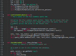
We have experience in developing both small to medium size software projects in a range of different programming languages. These days we mostly focus on the Python language, due to its extensive use throughout the scientific community, range of applications, rapid development time and near universal use as a plugin and scripting language for software in our industry.
We focus primarily on improving productivity and streamlining workflows when working with GIS software, model configurations and results, and large datasets. The primary aim is to reduce the time dedicated to repetative tasks and improve consistency. We have developed a range of tools and interfaces to do this, used by ourselves and others. These provide assistance with model schematisation, construction and review, as well results analysis and production.
Please contact us if you think that we could help you to improve your workflows, or provide you with a tool or setup that could improve your productivity. We are happy to discuss anything from setting up Excel workbooks with forms and VBA, bespoke scripts to assist in data processing and analysis, through to small desktop applications.